
So let me start by removing the acronym. GPS stands for Global Positioning Satellite. But it really is not one satellite. The term is used more broadly to describe all the 20 to 30 US based satellites used for navigational purposes, as well as most Earth based units that receive and use these satellite signals.
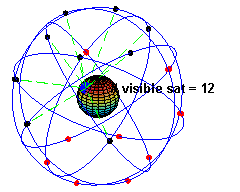 |
| Nice image courtesy of Wikipedia |
For basic triangulation, you need to have 2 known reference points (landmarks). Wherever I am, as long as I have line of site, I can then get the compass direction to each of my reference points. In geometry terms, I am just drawing an angled line from each of my reference points on a map, and find out where the 2 lines meet. Presto! I now know where I am as accurately as I measured the angles and know the exact locations of the reference points. It also turns out that we can do almost the same calculation if we know the distance from the 2 reference points, without knowing the angles.
And that, in a nutshell, is what the GPS satellites help with. Each GPS receiver has a circuit that can decode the radio waves from each satellite. The satellites embeds distance markers in the radio signals they send, so my GPS receiver can extract the distance from my position to each of the satellites. Also, satellites have known orbits, so even though they zip along at just under 9000 miles per hour, at any given time we know very precisely where they all are. The only difference from the previous example, is that we now use more than 2 reference points, and we not only get our latitude and longitude, but also altitude.
Not so complicated after all - is it?
Next post - I will tell you why it really is that complicated!

No comments:
Post a Comment